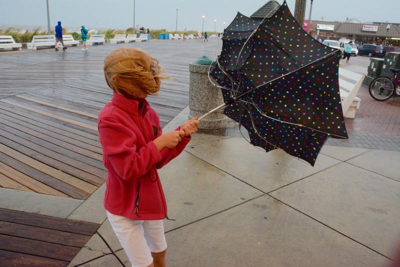
High winds and rain hit the Cape Region Sept. 3 as Tropical Storm Hermine edges its way up the coast.
A tropical storm warning is in effect for all of Delaware, and the storm is expected to cause coastal flooding, beach erosion and possible property damage throughout the next few days.
Gov. Jack Markell has declared a limited state of emergency for Sussex County effective 5 p.m., Sept. 3.
"Tropical Storm Hermine is a powerful storm that will bring significant rainfall and localized flooding, especially in coastal and Delaware Bay communities in Sussex County," Markell said in a statement Sept. 3. "I encourage Delawareans and visitors to our state to take precautions and stay tuned to weather forecasts and transportation updates throughout the weekend."
The storm also has forced Rehoboth Beach Patrol to evacuate the beaches during the last big holiday weekend of the summer.
By Sept. 3, the storm was reclassified as a post-tropical cyclone and located about 210 miles southwest of Dover, moving east-northeast at 15 mph with sustained winds of 65 mph. Gusts over 50 mph may occur along Delaware's coast, with the heaviest rain beginning Saturday afternoon, Sept. 3. Conditions are expected to worsen as the storm stalls off the coast Sunday, Sept. 4, and possibly through Sept. 5-6, depending on the storm's track and intensity, the National Weather Service states.
Residents should prepare for damage - uprooted trees, blocked roads and damage to roofing and siding - from tropical storm winds, the warning states.
Forecasters with the National Hurricane Center warn that once the storm stalls over the Mid-Atlantic off the Delmarva and New Jersey coasts Sunday, Sept. 4, it may gain strength and become a hurricane.
“It is still something we have to be very very wary of because we think this is going to restrengthen over the waters,” National Hurricane Center Director Rick Knabb said in a video update Sept. 3. “This is going to be a prolonged event, we're confident of that.”
Knabb said storm surge is a concern from southern New England to Virginia, and a variety of wind and water hazards along the coast can pose serious risks through Labor Day weekend and possibly until Tuesday, Sept. 6, or later.
“Sussex County may escape a direct hit, but the prolonged effects of this storm may be just as bad if not worse,” Sussex County Emergency Operations Center Director Joseph L. Thomas said in a press release Sept. 2. “Two to three days of rain, winds and tidal surge could really cause a lot of trouble for the beaches and low-lying communities. If this storm parks itself off our doorstep, whether it’s a direct hit or a glancing blow it really doesn’t matter. We’ll have flooding, wind damage, road closures, power outages, everything you would expect. The public should prepare now for those likely possibilities.”
Coastal flooding is expected with the high tides Sept. 3-5. Some areas of Delaware may see 4 inches of rain or more, which could also contribute to localized flooding. Sussex EOC warns areas that normally flood – Long Neck, Broadkill Beach and Primehook – could see tides 2 to 4 feet above normal.
Storm surge also is a concern, forecasters say. Rough surf is expected to produce a high rip current risk and large waves, which may cause significant beach erosion and breached dunes, the weather service states. Flooding may be severe along back bays as water accumulates with the high tides on Saturday, Sept. 3, and Sunday, Sept. 4.
As of 9:30 a.m., the University of Delaware's Environmental Observing System noted peak wind gusts of more than 30 mph at the Rehoboth Beach Boardwalk.
Officials at the Delaware Emergency Management Agency recommend Delaware residents, especially in coastal areas, check home emergency kits, fill gas tanks and secure outdoor objects that might be affected by strong gusts of wind. People in flood-prone areas should be ready to move to higher ground, officials say.
A limited state of emergency authorizes the Delaware National Guard to be on standby in coordination with DEMA. There are no driving restrictions in a limited state of emergency, but residents in Sussex County should watch for changing conditions.
Delaware Department of Transportation staff and equipment are also on standby. DelDOT officials warn Route 1 from Dewey Beach to Fenwick Island and on the Charles W. Cullen Bridge over the Indian River Inlet may close due to flooding and high winds.
Evacuation routes can be found at deldot.gov.
For local updates and forecasts, go to sussexcountyde.gov, weather.gov/phi and nhc.noaa.gov.
To stay updated on social media, follow Sussex County at: facebook.com/SussexCountyDE, facebook.com/SussexCountyEOC, and facebook.com/SussexCountyEMS on Facebook; and on Twitter at twitter.com/sussexde_govt, twitter.com/SussexCtyDE_EOC, and twitter.com/SussexCoDE_EMS.


