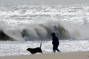
The Cape Region was spared the brunt of a winter storm that caused havoc in many coastal areas along the East Coast.
The National Weather Services had issued high-wind and coastal-flood warnings for the Sussex County area March 2 and March 3, but the highest tides occurred March 4 with some minor flooding.
Sustained winds reached 40 mph with gusts of 60 mph; winds started to subside Sunday morning. Drifting and blowing sand forced the closure of the Lewes public beach.
Rehooboth Beach spokeswoman Krys Johnson said the Streets Department had been on call 24 hours through the weekend for any downed tree limbs. She said trash cans have been removed from the Boardwalk and trash can lids have been removed from the cans on Rehoboth Avenue.
USGS teams deploy storm sensors
United States Geological Survey field crews are deploying storm-tide and wave sensors from Maine to Delaware to track and study a nor’easter forecasted to begin March 2.
The sensors will continuously measure wave height and tide levels and provide information on the timing, duration and extent of flooding. Data is collected four times per second, providing a detailed picture of the storm.
More than 25 USGS scientists will deploy over 50 sensors along the coast of Maine, New Hampshire, Massachusetts, Rhode Island, Connecticut, New York, New Jersey and Delaware.
The information gathered will help federal and state officials, emergency managers and coastal planners understand storm processes and ultimately build more resilient communities.
Data will help fine-tune and improve the accuracy of models that forecast storm surge, inundation, erosion, dune loss and other coastal changes. This information also helps guide recovery efforts, helping identify areas hit the hardest by the storm and inform decisions to improve structure designs and increase public safety.
“Nor’easters can cause higher storm tides than hurricanes in the Northeast and Mid-Atlantic,” said USGS New York Water Science Center supervisory hydrologist Ronald Busciolano. “Many of the highest recorded tides in these areas were from these types of storms. “The more real-world data we can collect on a variety of storms and tracks, the more precise and informed forecasts can be for future scenarios.”
All sensors will be collected next week—when it is safe to do so—and data will be analyzed and available in the following weeks. Data will be available via the USGS Flood Event Viewer.
The sensors are part of a new USGS mobile network of rapidly deployable instruments to observe and document storm-surge, waves and tides as they make landfall and interact with the coast. This USGS network is called Surge, Wave and Tide Hydrodynamics, also known as SWATH.
The USGS also operates a network of permanent tide gauges that provide real-time information through the National Water Information System.


