Tropical storm conditions will likely greet crowds arriving in the Cape Region for the last summer holiday weekend as offshore storms create hazardous, rainy conditions.
As Hurricane Hermine made landfall in Florida in the early morning hours of Sept. 2, it was downgraded to a tropical storm, but forecasters are expecting it to bring strong winds and waves to the East Coast through Labor Day weekend.
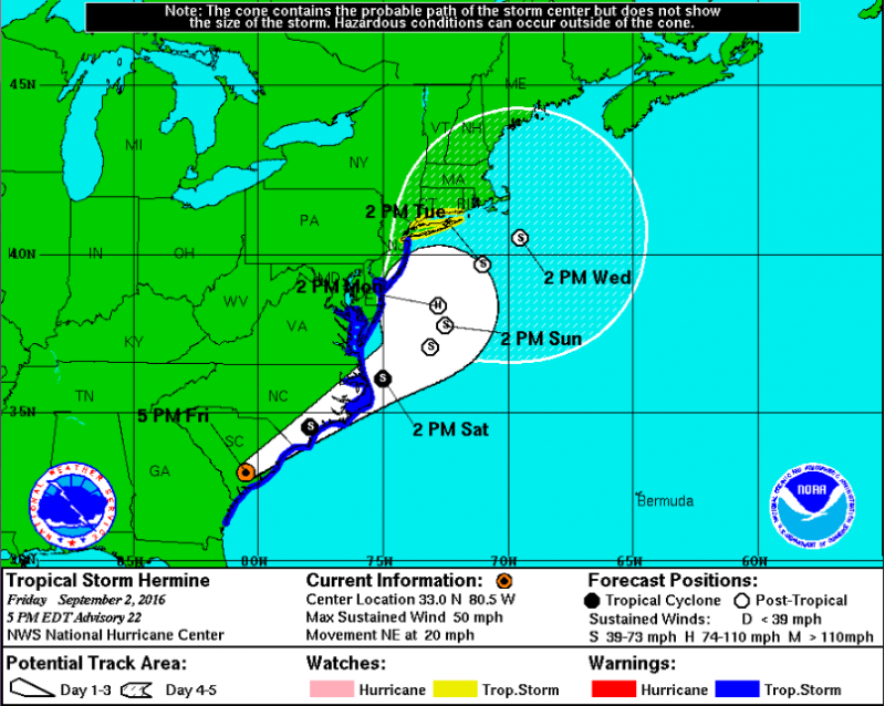
The National Weather Service has issued a tropical storm warning for the Delaware beaches, with Tropical Storm Hermine located about 620 miles southwest of Dover Sept. 2. Winds are forecast at 30 to 40 mph, with gusts of 50 mph or more Saturday afternoon, Sept. 3, through Monday evening, Sept. 5.
Residents should prepare for damage - uprooted trees, blocked roads and damage to roofing and siding - from tropical storm winds up to 73 mph, the warning states.
Rough surf, dangerous rip tides and coastal flooding also are expected through the weekend. Storm surges may cause up to 2 feet of water above ground, and flooding may be severe along back bays as water accumulates with the high tides on Saturday, Sept. 3, and Sunday, Sept. 4.
In the National Hurricane Center’s latest storm briefing Sept. 2, forecasters warn Hermine may become a hurricane after the storm's center moves offshore late Sunday, Sept. 4. Storm surges are possible along the coast from North Carolina to Connecticut.
Some areas of coastal Delaware and southern New Jersey may see 4 to 8 inches of rain. Heavy rain and flash flooding is expected Saturday, Sept. 3, and Sunday, Sept. 4, the weather service states.
The storm is moving northeast at 18 mph with sustained winds about 50 mph. It is expected to move into the Carolinas Saturday, Sept. 3, and then off the Mid-Atlantic coast later that night. The storm is expected to stall off the coast on Sunday, Sept. 4, and Monday, Sept. 5, before gradually moving away in the middle of next week, the National Weather Service states.
Rough surf and rip currents, along with onshore winds, blowing from the ocean to land, are expected to worsen throughout the weekend and remain through Tuesday, Sept. 6.
Officials at the Delaware Emergency Management Agency recommend Delaware residents, especially in coastal areas, to check www.weather.gov for the latest storm forecast, check home emergency kits, fill gas tanks and secure outdoor objects that might be affected by strong gusts of wind. People in flood-prone areas should be ready to move to higher ground, officials say.
Delaware Department of Transportation staff and equipment are also on standby. DelDOT officials warn Route 1 from Dewey Beach to Fenwick Island and on the Charles W. Cullen Bridge of the Indian River Inlet may close due to flooding and high winds.
Evacuation routes can be found at www.deldot.gov/information/projects/tmt/evac_map.shtml.
Beach closures are possible this weekend, depending on the strength of waves, wind and rip currents, said Rehoboth Beach Patrol Capt. Kent Buckson. Buckson and Rehoboth Beach Patrol Chief Matt Matsko said they will assess the situation Saturday morning, Sept. 3, before making a decision.
“Sunday will be the main day we’ll have issues,” Buckson said. He encouraged visitors to check conditions with lifeguards on arrival.
Matsko said they will be fully staffed this weekend, with about 40 to 50 guards patrolling just over 1.5 miles of beach. With the jetties in Rehoboth, strong rip currents - which can span 20 to 200 yards in length - will be a serious safety concern.
“Rip currents tend to form a lot and form very quickly around here,” he said. “It's definitely an issue. Almost 90 percent of the saves we make are from rip currents.”
With thousands of people on the beach for the last holiday of the summer season, closing the beach to swimmers isn't a decision that's taken lightly, he said. Buckson said beach closures are typical once or twice a year, usually in August or September.
“If we have the water closed, people aren’t going to be happy,” Matsko said. “But it’s safety first.”
Swimmers should swim only in designated areas patrolled by lifeguards. Breaking waves in beach swim zones will be larger than usual due to swells from tropical storm systems well offshore.
Dewey Beach Patrol Capt. Todd Frichtman said Aug. 30 his team has seen larger-than-normal swells with waves about 3 feet, even at low tide. He said on Aug. 29 the beach was flooded by storm surge and waves, and guards instructed people to leave the water and beach when they left at 5 p.m.
“My advice is whether you're an experienced swimmer, not an experienced swimmer, kids or no kids, swim within proximity of a manned lifeguard stand,” Frichtman said. “I also highly recommend that when the lifeguards are off duty, don't continue to swim. These conditions can bring up unexpected rip currents and longshore currents, and the wave-impact zones can be a hazard when getting in and out.”
Frichtman said Dewey Beach will have 20 to 25 lifeguards patrolling 1.1 miles of beach Labor Day weekend, and he also recommends visitors check in with the lifeguard to find out about current hazards and regulations.
Rough surf has already claimed a life. On Aug. 30, a 45-year-old Pennsylvania man visiting Assateague Island National Seashore was found unresponsive after swimming in rough surf. Despite help from nearby surfers, responding lifeguards and law enforcement, he could not be resuscitated and was pronounced dead at a local hospital, said Liz Davis, chief of interpretation and education at the park.
The incident occurred near a campground area in the Maryland portion of the park, where there are no lifeguards, Davis said.


