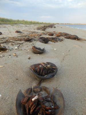
Sunny day in Cape Region as threat from Hermine decreases
It was a sunny, breezy Sunday in the Cape Region Sept. 4 as post-tropical cyclone Hermine lingered off the coast, but the threat of coastal flooding due to storm surge will remain a concern for coastal Delaware as Labor Day approaches.
A tropical storm warning remains in effect for the Delaware coast south of Slaughter Beach as the storm continues to produce strong winds and large waves offshore, but threats of rain and property-damaging winds have greatly diminished as the storm tracks well off Delaware’s coast, the National Weather Service states.
Gov. Jack Markell lifted a limited state of emergency, originally declared at 5 p.m., Sept. 3, about 8 p.m. Sept 4.
“I'm thankful that Tropical Storm Hermine has remained off the coast and its impact on our state has been minimal," Markell said Sept. 4. “We remain prepared to take any necessary action to protect public safety and property as Hermine remains in our region over the next few days.”
Hermine has been tracking farther east over the Mid-Atlantic, and was about 370 miles east-southeast of Dover with maximum sustained winds of 70 mph the evening of Sept. 4. The storm is expected to begin slowly moving north, then to the north-northwest through Monday, Sept. 5, the National Hurricane Center states.
Weather service forecasters say local threats from Hermine have decreased for the Delaware area, but the storm will maintain winds near hurricane intensity as it meanders over warm ocean waters. Water temperatures off the Delaware and New Jersey coasts are in the low-70s, data from the National Oceanic and Atmospheric Administration show. The threat for heavy rain and flooding has been reduced because of the hurricane's more easterly track, and the Sussex County Emergency Operations Center said it will not activate as planned Sept. 4, but will continue to monitor forecasts.
The beaches were windy with rough surf during the day, and red flag conditions in Rehoboth Beach warned people it was not safe to swim. On Sept. 3, beach patrol cleared the sand completely due to extreme high tides, and rough surf and dangerous rip tides have caused patrols to keep people out of the water.
In Dewey Beach, beaches remained open Sept. 4, but lifeguards said the ocean was closed to swimming.
“These are very, very serious surf conditions,” said Dewey Beach Patrol Capt. Todd Frichtman. He said the surf was too dangerous for rescue responses, and the wave energy impact too intense for people to enter without getting injured. Strong rip tides also have been occurring frequently along the coast thanks to Hermine.
About 10 a.m. Sept. 4, just before the morning high tide in Dewey Beach, the beach began to flood, Frichtman said. And storm surge has already done some serious damage.
“Our beach is completely eroded away to the front of the dune,” Frichtman said. “High tide brings water to the toe of the dune line.”
While Rehoboth and Dewey are closed to swimming, Frichtman reiterated that whenever visitors get to the ocean, they should check on current conditions with the lifeguard on duty and should always swim in front of a manned lifeguard stand.
Tropical-force winds are now expected by Monday, Sept. 5, and may linger into Tuesday, Sept. 6, depending on Hermine's pace as it makes its way northeast over the Mid-Atlantic. The National Hurricane Center reported Sept. 4 that tropical force winds extend about 230 miles from the center of the storm.
The University of Delaware's Environmental Observing System recorded peak wind gusts over 30 mph at the Rehoboth Beach Boardwalk Sept. 3. The system has recorded peak gusts of 19.5 mph Sept. 4.
Coastal flooding may occur around high tide Sept. 4 for both oceanfront and back bay communities. Forecasters say the greatest threat for localized flooding will happen during the Sept. 5 high tide, which will occur about 11:51 a.m., Monday, Sept. 5, at the Indian River Inlet, and at 11:01 a.m. and 11:20 p.m., Monday, Sept. 5, at Rehoboth Beach. However, storm surge warnings for the Delaware coast have been lifted, and the National Hurricane Center now warns the Long Island area will get the brunt of large waves produced by Hermine.
For local updates and forecasts, go to www.sussexcountyde.gov, www.weather.gov/phi and www.nhc.noaa.gov.


